A powerful quake beneath the water rattled the Caribbean late Saturday, leaving scientists scurrying to determine the exact scope of the threat. As the waves start to come in, some coasts prepare for impact.
A huge earthquake measuring 7.6 on the Richter scale struck north of Honduras late Saturday, prompting tsunami warnings in numerous coastal areas. The earthquake struck at 23:23 UTC on February 8, 2025, with an epicenter at 17.8°N, 82.5°W, and a depth of 33 kilometers (20 miles).
The earthquake recorded tsunami waves, which triggered an alarm for specific coastal locations. According to the Pacific Tsunami Warning Center (PTWC), dangerous waves between 1 and 3 meters above tide level are forecast along Cuba’s coast. Smaller waves, measuring between 0.3 and 1 meter, might hit Honduras and the Cayman Islands.
The authorities are actively watching sea-level gauges to determine the exact magnitude of the tsunami risk. The PTWC stressed that real wave heights may vary depending on local topography and undersea terrain. Barrier reefs and atolls may incur far fewer consequences than expected.
Estimated Tsunami Arrival Times

The first tsunami waves are predicted to reach impacted areas within hours on February 9. The estimated arrival timings (UTC) include:
Locations: Puerto Cortes, Honduras (00:22), Trujillo, Honduras (01:08), Santa Cruz del Sur, Cuba (03:00), and Nueva Gerona, Cuba (03:50 UTC).
A tsunami is made up of several surges rather than a single wave. Some waves may be greater than the first, lasting anything from five minutes to an hour. The hazard might last for many hours or more.
Notable quake, preliminary info: M 7.6 – 209 km SSW of George Town, Cayman Islands https://t.co/uIdsEybY34
— USGS Earthquakes (@USGS_Quakes) February 8, 2025
Officials have verified that there has been no tsunami warning issued for the United States. However, coastal surveillance will continue as a precautionary measure. Governments in the impacted regions are asking coastal people to remain vigilant and heed local officials’ recommendations. Evacuations may be required in some regions, depending on the intensity of the waves.
The United States Geological Survey (USGS) also mentioned the quake in a social media post, writing, “Notable quake, preliminary info: M 7.6—209 km SSW of George Town, Cayman Islands.”
🟣International threat messages continue for Cuba, Honduras, & the Cayman Islands.
A tsunami is measured in Mexico, Isla Mujeres, at 0103 UTC, at 3 cm / 1.2 in. While that sounds small, it’s a necessary confirmation that a tsunami is occurring. https://t.co/npoUHxX900 for more pic.twitter.com/LhlBd2DBkd— NWS Tsunami Alerts (@NWS_NTWC) February 9, 2025
Hours after the massive earthquake shook the Caribbean, the US National Tsunami Warning Center published important updates, calming worries in certain areas but cautioning others. In a series of social media messages, the agency certified that the tsunami threat has passed for the United States and its allies.
According to one update, “The tsunami threat has passed based on the most recent modeling and information.” There are currently no alerts for the United States or international partners. The agency discovered unusual currents in some areas. Exercise standard caution.”
Despite this, notifications remained in place for certain localities. Another bulletin noted continuous surveillance in Cuba, Honduras, and the Cayman Islands. At 01:03 UTC, officials reported a modest tsunami wave of 3 cm (1.2 inches) near Isla Mujeres, Mexico. The reading verified that tsunami activity had occurred, despite its low magnitude.
The Tsunami Advisory for Puerto Rico and the US Virgin Islands is now canceled.
While alerts have ended, strong and unusual currents may continue. Be careful near the water and use caution.
Refer to the latest information from local emergency management.
— NWS Tsunami Alerts (@NWS_NTWC) February 9, 2025
Meanwhile, a third update comforted Puerto Rico and the United States Virgin Islands residents by reporting that the tsunami alert for these areas had been lifted. However, officials warned that strong and unexpected currents might persist, urging people to exercise caution near the sea.
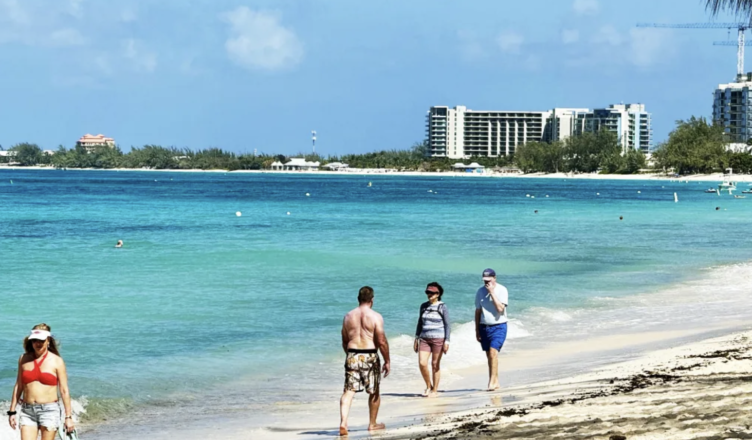
As tsunami warnings spread across the Caribbean, the Bahamas Department of Meteorology issued a special weather statement alerting coastal populations about the potential consequences.
The report, issued at 7:45 PM EST on February 8, 2025, stated that the 7.6-magnitude earthquake hit around 130 miles south-southwest of George Town, Cayman Islands. In response, the Pacific Tsunami Warning Center (PTWC) issued tsunami warnings for various countries in the Caribbean, Central America, and South America.
Officials have cautioned that rising sea levels may impact Southeast Bahamas islands such as Ragged Island, Crooked Island, Acklins, Mayaguana, and Inagua. The alert also applied to the Turks and Caicos Islands.
We warned residents near the eastern and southern shorelines of these locations to monitor any unusual changes in coastal conditions between 7:30 PM and 9:30 PM EST.
Authorities continue to monitor the situation, asking citizens to remain up to date via official meteorological reports.